The West Coast
Simplification and barrier coast. The dynamic coast – coastal erosion and protection.
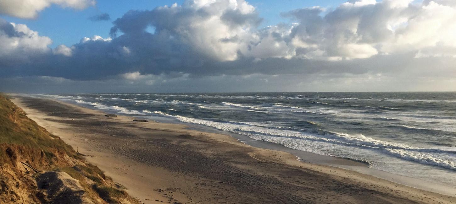
This locality comprises about 50 km of the west coast of Jutland situated in Lemvig and Holstebro municipalities, extending from Vedersø Klit in the south to Thyborøn in the north (Figure 37-1).
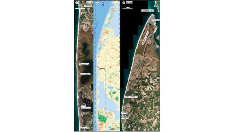
Figure 37-1: The west coast with the towns and localities mentioned in the text. This locality is very extensive so the map has been divided into two (north and south) with inset maps.Photo:Geopark Vestjylland
The west coast of Jutland forms part of the eastern coastline of the North Sea. This stretch of coast is subjected to powerful wave action because of the dominant westerly and north-westerly winds and its exposed location. This results in a very dynamic coastline with the transport of enormous amounts of material along the coastal zone. These conditions characterize the entire east coast of the North Sea from Holland in the south to Skagen at the “top” of Denmark in the north. Almost this entire stretch is a simplification coast, characterized by the fact that headlands are eroded whereas bays and inlets become closed by the deposition of transported material. Waves shape the coastline that becomes less uneven; it becomes simplified.
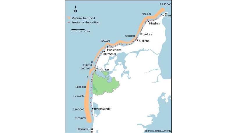
Figure 37-2: Material transport along the west coast of Jutland. The map shows the annual sediment erosion and transport (in cubic metres). Note the large transport into Thyborøn canal (after Danish Coastal Authority (website)).Photo:Geopark Vestjylland
There are other factors than coastal erosion and material transport that control the shape of the coast. The eastern coast of the North Sea has been affected by significant changes in sea level as a result of isostatic elevation of the land and eustatic changes in sea level since the last glaciation. This is described in more detail under site 48 (The underwater landscape). The coast from Holland to Skagen can be subdivided into three sections on the basis of the grade of relative elevation of the land and the effect of the tide. A southern section comprising the Wadden Sea in Holland, Germany and Denmark where a relative rise in sea level and large tidal range have formed extensive areas of wetlands behind a row of unconnected barrier islands. A central section from Blåvands Huk to Lodbjerg that is characterized by a small tidal range and minor variations in relative sea level. The coast of GPWJ is located in this stretch. It is a well-developed barrier coast where connected spits separate lagoons from the sea. Examples include Ringkøbing Fjord just south of the geopark and Nissum Fjord, lake Ferring Sø and Nissum Bredning inside the geopark. Finally the coast north of the geopark has been subjected to considerable isostatic elevation of the land and has no barrier coastal features or lagoons.
Photo:Mads Kjærstrup
A closer look the locality reveals several interesting details in addition to the overall picture of a simplification and barrier coast. In the south, at Husby Klit (Figure 37-3 and 37-6), there is a stretch of coast without any lagoons. The coast here consists of glacial hills (part of Skovbjerg hill island) covered by wind-blown sand with well-developed sand dunes (described under site 33 – Husby Klitplantage). There is no coastal protection in this area so the coast develops naturally. The coast is being eroded, which is evident in a small cliff profile (site 27 – The Græm Profile). At Nissum Fjord there is a very well-developed barrier coast where spit growth and later isthmus formation have cut-off a large lagoon (site 38 - Nissum Fjord). This stretch of coast has been greatly modified by human activity. For example, the fjord is linked to the sea via a sluice at Thorsminde, and sand dunes on the isthmus have been converted into a continuous ridge of sand that protects the low-lying areas at Nissum Fjord. Between Fjaltring (Figure 37-5) and Ferring the glacial landscape has been eroded to give impressive steep cliffs that culminate at Bovbjerg (site 1 – The Bovbjerg Profile). These glacial uplands comprise one of several high areas along the west coast of Jutland that are separated by low-lying areas of marine foreland. This coastal section has long been subjected to erosion and has therefore been protected by groynes and other structures. The glacial hills disappear north of Ferring and from here to Thyborøn the coastline is essentially a barrier and lagoon coast formed by the development of spits and isthmuses that have cut off the lagoons lake Ferring Sø and Nissum Bredning. This area has been subjected to relative elevation of the land so that there are large areas with marine foreland (site 29 Veserne – Plet - Engbjerg). The coast has been significantly modified by human activity. The most marked interference by man is at Harboøre where the original isthmus, which was breached by a storm in the 1800s, is now kept permanently open by a canal. The entire coast here is dominated by coastal protection structures and has been modified so much that it can be considered to be an “engineered landscape” (Figure 37-4).
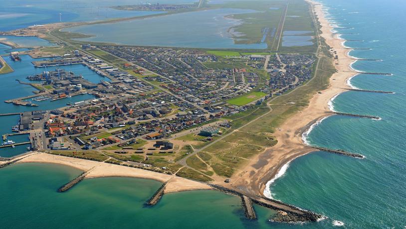
Photo:Thyborøn Port
Figure 37-2 illustrates material transport along the west coast of Jutland. In the geopark area the entire coast is subjected to erosion and it is evident that enormous amounts of sediments are transported by waves and currents. Between Ferring and Thyborøn material transport is dominantly to the north and the eroded material is transported through the canal at Thyborøn and into Nissum Bredning where it is deposited as sand banks. These form a huge delta-like structure. South of Ferring transport is towards the south and a large proportion of the material is deposited at Blåvands Huk and on Horns Rev. It is noteworthy that this pattern of material transport is partly controlled by mankind, since the role of Nissum Bredning as an area for sediment deposition depends on the canal at Thyborøn being kept open artificially.
Since the coast is subject to major erosion, the Danish Coastal Authority uses considerable resources for coastal protection initiatives. This used to be in the form of structures like groynes, barriers and revetments, but today the strategy is mainly to replace the eroded sand with new supplies. Sand is either pumped onto the beach or deposited in shallow water. This initiative has reduced coastal erosion to a minimum at the present time.
Overall this locality is a splendid example of a simplification coastline in a glacial landscape. Between the highland areas formed by the glacial deposits at Husby, Bovbjerg and Thy, material transport along the coast has resulted in the construction of impressive natural barriers (Nissum Bredning, lake Ferring Sø, Nissum Fjord). This type of coastline is very different from the North Sea coast further north and south. The stretch of coast in GPWJ has been considerably modified by mankind, but this only serves to emphasize the power of nature in the area.
Parts of the coast have been nominated as a Natura 2000 bird protection and habitat site, and there are also Ramsar areas and nature reserves. Dune heathland (site 33 Husby Klitplantage) is a particularly characteristic type of landscape. The area is part of NGI 76 and NK 80. Several stretches along the coast are protected conservation areas.