The Bovbjerg Profile
Photo: Bovbjerg Fyr
International Geosite
The Bovbjerg profile is a unique coastal cliff in Geopark West Jutland. Here the geological profile of the Main Stationary Line (MSL) during the latest ice-age, Weichsel, can be seen.
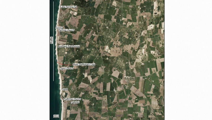
Photo:Geopark Vestjylland
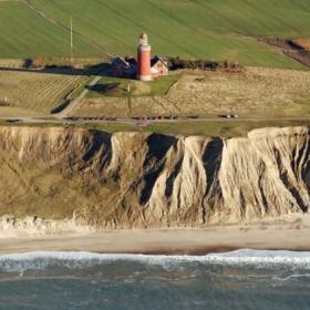
The Bovbjerg Profile is exposed in a coastal cliff that extends for about 6 km along the west coast of Jutland from Ferring in the north to Fjaltring in the south (Fig. 1-5). The most important part of the profile is the roughly 3 km long stretch from Ferring to Trans Church. The Bovbjerg profile is unique in that it is the only coastal exposure through the MSL of the Weichselian glaciation (Fig. 1-1, 1-2). The profile contains sections through an entire series of glacial landscapes from depressions to terminal moraines (hill-hole pair), outwash plains and hill islands. The locality therefore contains an illustrative section through the MSL and the entire glacial sequence represented in GPWJ. The different layers in the cliff and the various landscape elements are clearly visible. There are deposits from the Elsterian, Saalian and Weichselian glaciations, as well as good example of glaciotectonics.

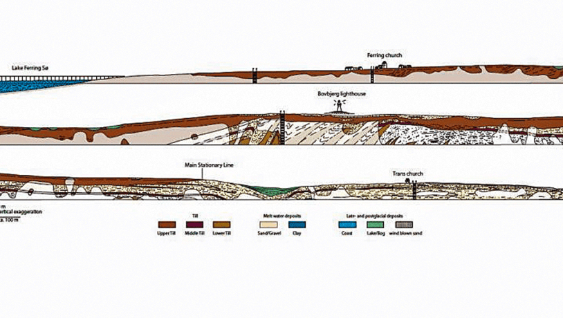
Photo:Geopark Vestjylland
The cliff profile at Bovbjerg is the only place in Denmark – and perhaps in the world – that exposes a section through the MSL of the Weichselian glaciation (Fig. 1-3). This line marks the limit of the Main Advance of the Weichselian ice 23.000-21.000 years ago. This landscape feature can be followed through much of Denmark. The line extends through GPWJ from Bovbjerg in the west to river Karup Å in the east, and it is a feature of several other geopark localities. Elements of the different types of glacial landscapes developed around it are features of many of the localities, and the MSL and its related series of landscapes are the main theme of the geopark. The Bovbjerg Profile is clearly the most important locality in the geopark concerning ice age geology.
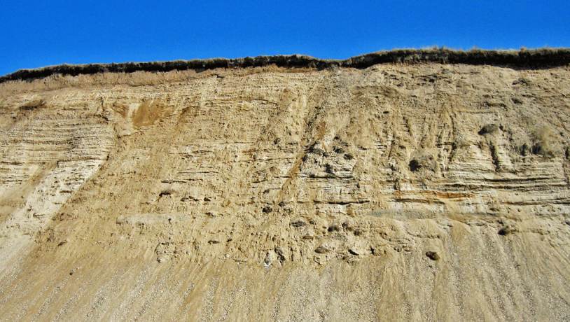
Photo:Mads Kjærstrup
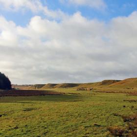
From lake Ferring Sø the terrain gradually rises to Bovbjerg lighthouse that is 40 m above sea level. Lake Ferring Sø is a depression and Bovbjerg lighthouse is located on top of a terminal moraine. The gradual slope up towards the top of the terminal moraine is disturbed by a series of small east-west ridges that are equivalent to glaciotectonic thrust sheets in the cliff. The terminal moraine extends for about 1 km south of the lighthouse where it abuts an outwash plain. This boundary between the terminal moraine and the outwash plain marks the MSL. The precise location of the line is not clear when you are standing on the top of the cliff, but it is where there is a change from clay-rich soil to sandy soil. South of the stream Dybå the land rises to the hill island of Fjaltring Bakkeø, deposits of which can be seen in the cliff at Fjaltring.
The coastal cliff at Bovbjerg represents a continuous profile that reveals the structure of the landscape and the composition of its components. The northern part of the profile, from Ferring to just north of Bovbjerg lighthouse, is not so well exposed but consists dominantly of clayey till. The central part of the terminal moraine, about 200-300 m north and south of the lighthouse, is strongly deformed. Outwash sediments and moraine deposits have been folded and faulted into glaciotectonic thrust sheets. The thrust sheets strike east-west and dip to the north, corresponding to formation by ice pressure from the north. The thrust sheets were emplaced during advance of the glacier that formed the MSL. After up-thrusting the sheets were overrun by the ice which has deposited a layer of basal till over them.
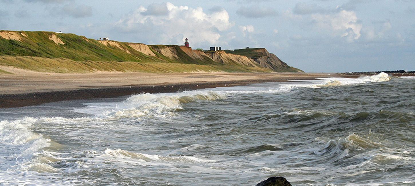
Some distance south of the lighthouse, where the cliff exposures are excellent, the layers are again close to horizontal. About 1 km south of the lighthouse the MSL is clearly visible in the cliff where the uppermost till layer wedges out and disappears (Fig. 1-3). South of the MSL the cliff consists dominantly of sand and gravel meltwater deposits, but at Fjaltring there is a low cliff with, amongst others, clayey meltwater deposits. Historically this stretch of coast has been subjected to powerful erosion (see site 37 – The West Coast). The coast is now protected by a series of groynes and erosion has subsequently decreased, but it is still adequate to keep the profile open. From one year to the next there can be major changes to the profile because of landslips - especially as a result of storms and high water levels. Interesting elements of the landscape along the cliff are several marked erosional gullies (Fig. 1-4). These were originally formed by large landslips but have become the course for running water (seepage of groundwater or drainage) that has eroded deep into the soft sediments. This kind of landscape is unique in the geopark and is seldom developed in low-lying Northwest Europe.
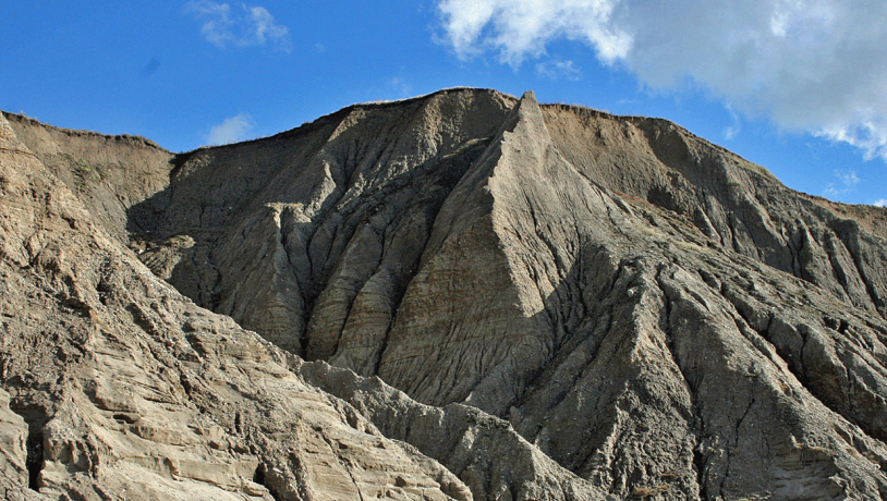
Photo:Mads Kjærstrup
The layers in the cliff consist of till and meltwater deposits. The oldest deposits in the cliff occur at Fjaltring where meltwater clay has been referred to the Elsterian glaciation. Equivalent deposits are found at several other localities in the geopark (e.g. Odby, Toftum). Between Trans and Ferring there are three different tills: lower, middle and upper. The lower till comprises a clayey till from the Saalian glaciation which occurs here and there in the lowest part of the profile and in the thrust sheets. The rest of the sequence was deposited in the Weichselian glaciation. The lower till is overlain by an upward-coarsening succession of outwash sediments that were probably deposited when the Kattegat Advance approached the area about 31.000-29.000 years ago. This sequence is characterized by the presence of reworked lignite (brown coal) of Miocene age. The middle till consists of clayey till that was deposited during the Kattegat Advance some 29.000-27.000 years ago. This layer can be followed almost continuously in the central part of the profile. The unit is overlain by coarse-grained deposits with many stones of northerly provenance (e.g. from the Oslo area). This unit also comprises the meltwater plain south of the MSL.
The upper till consists of moraine clay and can be followed from the beach at Ferring to the MSL. It was deposited during the main Weichselian advance that took place 23.000-21.000 years ago. The till consists of several units that reflect that the ice margin was not stationary but fluctuated in response to climatic changes. As a section through the MSL the Bovbjerg profile is of international research interest. This is reflected by its nomination as Geosite 4-4. It has also been identified as a National Geological Interest area (NGI 76) and National Coastal Landscape area (NK 80), and is listed as a “Valuable Geological Area”. Part of the cliff profile south of the lighthouse has been preserved.
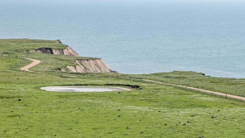
Photo:Henrik Winther Krogh
The coast around Bovbjerg has been subjected to erosion by the sea for many years. The churches at Trans and Ferring are now quite near the cliff, but when they were built about 900 years ago they were probably located about 1 km inland. Coastal protection started in the late 1800s when the first groynes in the world were built here in 1875. To start with the groynes were built to protect the coast north of Bovbjerg, but they have since been extended to cover the entire section (see site 37 – The West Coast). This stretch of coast used to be considered to be very dangerous for sailors because of the frequent storms and the absence of harbours and inlets. It was called the “Iron Coast” because of the many shipwrecks. Bovbjerg lighthouse was built in 1877 to protect ship traffic along this treacherous coast. The cliff at Bovbjerg is an important tourist attraction, partly because of the lighthouse, which contains an art gallery, café and exhibitions of the local geology, amongst other things. The lighthouse is mainly staffed by volunteers and is a focal point for cultural events. More than 40.000 people visit the lighthouse each year, and most of them enjoy the superb views from the top of the tower.