19. Odby Till Plain
Till plain from the last glacial advance in the Weichselian.
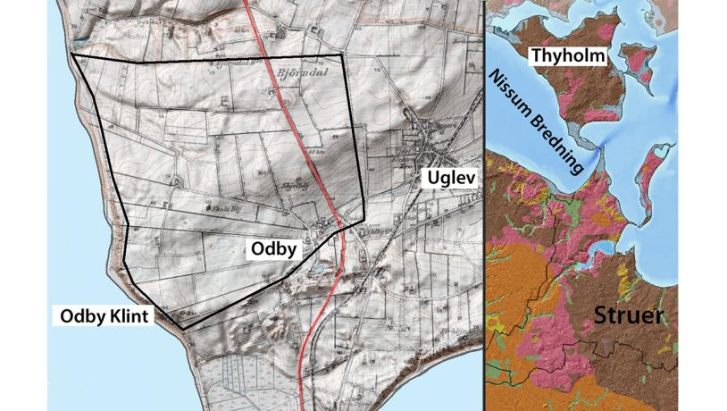
Figure 19-1. The fields fan out from the village of Odby. The walls between the fields were established in the early 1800´s. They comprise a valuable cultural memento and are protected by the Museum Law. Photo:Geopark Vestjylland
The peninsula Thyholm which lies north of Nissum Bredning comprises the most northerly part of the geopark. In the overall geological model for the glacial landscape series, Thyholm represents an excellent example of a till plain landscape that is typically located at some distance behind the marginal area of a glacial landscape series. The MSL, and the outwash plains in front of it, the dead ice and meltwater landscapes, the terminal moraines formed by glacial re-advances and the source depressions (hill-hole pairs), are replaced here, some 15 km north of the MSL, by a smooth, more homogeneous till plain landscape.
Photo:Geopark Vestjylland
The southern part of the peninsula has a weak east-west trending terminal moraine, and the landscape just south of the village of Odby has a gentle dead-ice and meltwater character, but north of Odby it is dominated by a smooth till plain that covers the rest of Thyholm. The geological differences between the glacial landscapes north and south of Nissum Bredning have had a marked influence on the development of cultural history in the region.
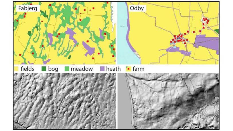
Figure 19-3. Land use in the early 1800´s. The dead ice landscape to the left (site 18) had widespread individual small farms whereas the more fertile basal moraine landscape to the right has a greater concentration of farms. Digital elevation models below show the same areas on the same scale.Photo:Geopark Vestjylland
The till plain is composed of compact, sandy-clay till with local sand lenses. The upper part is reddish-brown and lime-poor, while the lower part is grey and calcareous. Analysis of the small pebbles indicates that there is a large content of crystalline rocks. The orientation of the pebbles and glacial deformations indicate that the upper till was deposited by ice advance from the northeast, most likely in association with late Weichselian Main Advance. This relatively characteristic till can be seen in at least seven cliff profiles along the coast of Thyholm. The thickness of this till unit in the cliff profiles varies between 1 and 18 m.
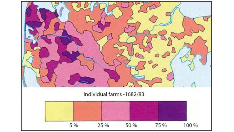
Figure 19-4. Since the Middle Ages the fertile clay-rich moraine soil north and east of the MSL has been suitable for the development of villages with communal land use. The dead ice landscapes just north of the MSL and the sandy soil on the outwash plains and hill islands has, on the other hand, only been able to support spread agriculture with small, spread farms.Photo:Geopark Vestjylland
This till plain makes up most of the agricultural soil on Thyholm and therefore also at the village of Odby. In the extensive survey and valuation of all agricultural land in Denmark before the land reforms in about 1800, all the land around Odby was classified as cultivated, and its quality was assessed as being near the top of the 24-scale. From a geological point of view it is noteworthy that a large connected area on a till plain in both the large registers (survey and valuation of all agricultural land in Denmark - 1688 and 1844) are recorded as continuous fields (cultivated soil with corn) and of high quality – in comparison to the soil south of Nissum Bredning where the fields are spread between uncultivated areas (meadows, bogs and heathland) and of poorer quality (Figures 19-3 and 19-4).
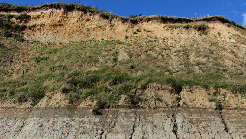
Photo:Geopark Vestjylland
The site is a good example of part of the glacial landscape series – here till plain – but also illustrates the links between topography and type of soil, which is another way of saying between the type of glacial landscape and cultural history. The development of cultural history in western Jutland has taken place at a slower pace than in eastern Jutland. In the west, significant elements in the agricultural systems, and in the pattern and style of building, survived from the Early Middle Ages up to the land reforms and the industrial revolution. Throughout the geopark there is a clear relationship between the geology and the development of cultural history, just one of which was outlined above.